Advanced Android
大约 12 分钟
Advanced Android
Image Uploader
- 请求互联网访问的使用权限
- 更新 build.grade 和 libs.versions.toml 并同步
- 设置与FastAPI连接的POST方法
- 创建一个可序列化的数据模型:数据类
PostModel(val data: String) - 设计图片上传界面
- 将Uri转换为位图,并将位图转换为字节数组,然后编码字节数组为字符串,并将数据模型发送到FastAPI
在FastAPI
- 创建数据模型
- 直接将byteArray保存到图像文件中
Google Play Services
- 谷歌Play服务是一套为Android设备提供的云服务和API
- Allows you to integrate various services from Google into the mobile app
- 谷歌的一些服务包括
- Location detection
- Geocoding and reverse geo-coding
- Maps API (e.g. navigation, street views)
- Google Drive for cloud storage
- Google Wallet for online payment
Accessing Google APIs
要访问各种Google API,您需要创建GoogleApi子类的一个实例。
- 它们自动管理连接到谷歌应用商店服务。
- 离线时排队请求。当有连接可用时按顺序执行。
- GoogleApi对象也易于创建,因此您可以根据需要实例化它们以访问Google服务。
要访问不需要 API 授权的服务,请获取该服务的客户端对象的实例,并将其传递给当前的 Context 或 Activity。
要访问需要API授权的服务,首先登录用户并请求权限。然后获取服务客户端对象的实例,将其传递给GoogleSignInAccount和当前的Context或Activity。
Location Detection
位置检测是智能手机最常用的功能之一
- Maps, transportation and navigation
- Location-based social networking
- Tracking
手机可以利用多种数据源来检测位置
- GPS (Global Positioning System)
- Information of base stations (Cell ID)
- Wi-Fi + IP Address
Android 提供简单的 API,通过结合来自不同来源的输入来返回用户的当前位置
- Android Framework's Location API (android.location) -> Not recommended for access location
- Google Location Services API (com.google.android.gms.location) -> Preferred way to add location-awareness
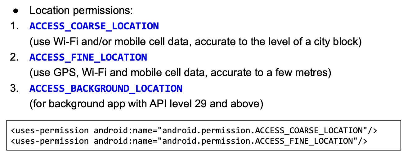
如果您的应用需要使用位置服务,则需要请求用户的许可

Google Play Services Location APIs

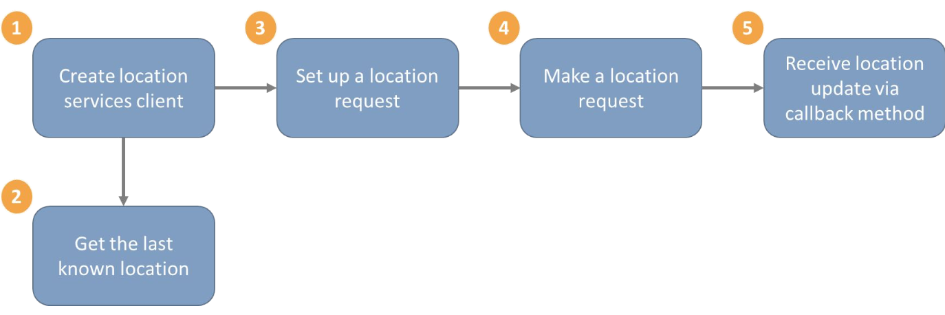
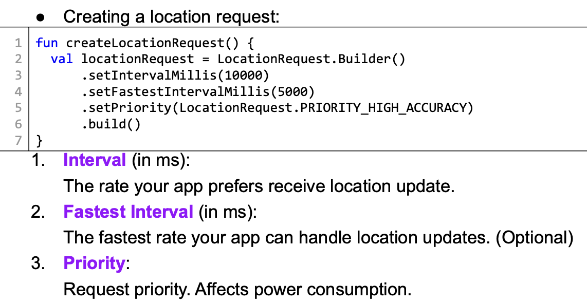
Set Up a Location Request
- 如果您的应用需要请求位置更新,设备需要启用相应的系统组件(例如GPS或Wi-Fi扫描)。
- 您的应用程序不是直接启用服务,而是指定要请求的参数。

Using Google Maps
您可以使用 Google Maps Android API 在您的应用中嵌入交互式地图
Google Maps functions include:
- 提供交互式地图,包括3D地图、卫星视图、地形视图、路线图等。
- 允许叠加不同的组件,例如标记、多边形等。
- 控制用户的视图,例如旋转、缩放、平移
- Street view
Geocoding and Reverse Geocoding
这两个功能都可以通过使用Android中的Geocoder类来实现。
- Geocoding: Converting an address to a geographic location (latitude/longitude)
- Reverse Geocoding: Converting a geographic location (latitude/longitude) to an address
在移动应用程序中,您可能希望让用户输入地图上的位置,而不是获取当前位置。
- 考虑一个用于获取司机接送或食品配送投递的应用程序。
- 然后您需要将地点名称翻译成地理坐标(地理编码)。
在移动应用中,你可能需要将地理位置转换为街道地址(反向地理编码)。
- 例如,获取当前位置的名称,然后在网络上搜索附近的餐厅。
- 要使用反向地理编码,您需要一个精确的地理位置,因此您应该请求ACCESS_FINE_LOCATION权限。
- 您也可以使用Geocoder类来执行反向地理编码。
getFromLocation() 函数是阻塞的,可能需要几秒钟才能响应。
- 您不应该在UI线程上执行此操作。
- 相反,您应该使用其中一种异步访问方法,例如:
- AsyncTask
- 意图服务(IntentService)与结果接收器(ResultReceiver)或本地广播(LocalBroadcastManager)
- Coroutine
Gradle
Gradle 是 Android 应用程序的官方构建工具
- 它帮助您构建(编译)、测试、运行和打包您的应用程序
- 它通过Android Gradle插件集成到Android Studio中
- 也可以从命令行独立执行
Benefits of Gradle
- Configure and customize the build process
- 创建具有不同功能、设置或参数的同一项目下的不同版本的应用程序
- 轻松将第三方模块集成到您的应用程序中
ProGuard
Pro Guard 是一个可以帮助您缩小、优化和混淆应用程序代码的工具, 它通过删除未使用的代码、使用语义上晦涩的名称重命名类、字段和方法来实现这一点.
Why?
- Creates an APK file with smaller size
- Makes the app more difficult to reverse engineer